DJI Mavic 3 Multispectral Drones for Survey and Crop Monitoring
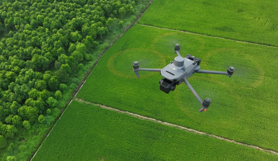
Drones are presently employed in land surveys, agricultural surveys, and environmental assessments in the UK. Currently, one of the drones used for this purpose is named DJI Mavic 3 Multispectral. Unlike normal camera drones, this drone captures data that cannot be observed with the naked eye. Its primary use includes agricultural surveys, land surveys, and research.
The Mavic 3 Multispectral UAV assists users in determining plant health, soil quality, and crop development. The device flies over farmlands and soil, giving users information that is not readily available when accessed on foot.
What Makes Multispectral Drones Different
A multispectral drone takes photos using specialized cameras to capture more than a normal color photo can provide. The DJI Mavic 3 Multispectral comes equipped with multiple sensors to detect visible light and near-infrared light. These values help indicate the level of plant health and areas where issues are emerging.
A healthy plant will reflect light in a different way to an injured one. Using this information, the user is able to detect whether there is a problem with watering, illness, or poor soil.
This kind of data is very commonly used in precision farming. It assists in minimizing waste as well as maximizing sustainable use of the land.
See also: Timeless Interior Ideas for Homes Boasting Elegant Shaker Kitchens
Design and Build Quality
The DJI Mavic 3 Multispectral comes with the same compact design that the Mavic series has always had. Not only is the drone easy to transport from one location to another, but deploying it also takes little time. Nevertheless, the drone has been built with capabilities to perform even professional duties.
The drone is sturdy and balanced. The closure of its arms is reliable, and it has been crafted for efficient flying. This is essential for accurate data collection, which relies on smooth motion.
The controller works well. It displays real-time data. It also enables users to design flight plans with confidence. Such a controller facilitates repeated surveys and repeatability.
Camera System and Data Capture
The major highlight of the Mavic 3 Multispectral drone is the camera. It is a combination of a normal RGB camera and multispectral cameras. The former takes normal photos, while the latter takes pictures that help in determining plant health.
This allows comparisons to be made between images and data maps. The UAV is able to provide detailed images of a field, which also indicates areas that need to be focused on.
The data that is obtained can be employed together with mapping software. This enables the data to be turned into understandable reports that help with planning and decision-making.
Flight Performance and Accuracy
The Mavic 3 Multispectral has robust flight capabilities. This drone is meant to fly smoothly and remain stationary even in light air currents. Such flight capabilities enable higher image and data quality.
Flight time can be used to survey medium to large areas in one outing. This saves on the number of landings and battery changes. In major projects, additional batteries enable one to get back to work with minimal delays.
The UAV also has a number of positioning systems that enhance accuracy. Accuracy is key when it comes to mapping and repeated flights.
Use in UK Farming and Land Management
The Mavic 3 Multispectral is used by farmers, agronomists, and land managers in the UK for crop analysis, drainage mapping, and soil testing purposes. This increases the efficiency of production and eliminates unnecessary treatment.
It enables users to specifically apply fertilizers or water based on the areas that need attention. This will save both costs and the environment. It will also help users keep track of their practices.
The drone is also involved in scientific research and conservation studies, where land condition is of great significance.
Rules and Responsible Use
Drones in the UK have to be flown in accordance with Civil Aviation Authority regulations. Flying a drone for professional purposes may involve registration and training. Flying a drone has to be done in a safe manner and without endangering other human beings or exceeding airspace regulations.
Knowing and observing these guidelines can prevent harm to people and to property and still enable the use of drones.
A Useful Resource for Data-Driven Insights
The DJI Mavic 3 Multispectral is not just any consumer drone. This is a productive tool built specifically with data collection in mind. As such, the multispectral drone, specifically built for agricultural or land-use professionals, delivers good data, faster surveys, and clearer insights.